|
|
|
|
CIAO DATE: 4/00
Through A Shutter Darkly: The Tangled Relationships Between Civilian, Military and Intelligence Remote Sensing in the Early U.S. Space Programs
John G. Cloud and Keith C. Clarke
Secrecy and Knowledge Production
Judith Reppy, Editor
Peace Studies Program, Cornell University
Occasional Paper #23
October 1999
Introduction
On September 12, 1962, on the eve of the Cuban Missile Crisis and 15 years into the Cold War, President Kennedy gave a celebrated speech accelerating the U.S. space program. One paragraph, in particular, resonates with a workshop on “Secrecy and Knowledge Production”:
We choose to go to the Moon. We choose to go to the Moon in this decade and do the other things, not because they are easy but because they are hard, because that goal will serve to organize and measure the best of our energies and skills, because that challenge is one that we are willing to accept, one we are unwilling to postpone, and one that we intend to win, and the others too (Kennedy 1962, emphasis added).
The other things to which the President repeatedly referred may now be considered a tacit acknowledgment that, less than five years after the launch of Sputnik I, the United States had created an extraordinary series of reconnaissance satellites, and that the program, called CORONA, had already moved from experimental to operational status. Operational space-borne reconnaissance completely transformed the context and progress of the Cold War–but it was conducted at the highest and most compartmentalized levels of secrecy in the history of the nation.
The very possibility of reaching the Moon publicly was inevitably linked to the technological innovations that allowed secret observation of the Soviet Union and the rest of the world, but the nature of that linkage remained hidden for the next third of a century. In late 1995 the CORONA program was declassified. Public release of previously deeply classified data now makes it clear that the coupling of open and secret, as in the Apollo program and CORONA, was not unusual, and was in fact the general case. Such a coupling–now referred to as the “Dual Use” policy–extends through U.S. space history. Since 1968, for example, the Civilian Applications Committee (CAC), a federal interagency committee, has provided federal civil agencies access to classified reconnaissance information. The roots of such contemporary programs as Medea, which provides top U.S. scientists access to classified space-borne intelligence data for tackling global environmental problems (Richelson 1998), may be found in the secret relationships between ARPA, NASA, and the Intelligence Community forged in the very earliest days of the U.S. space program.
The goal of this paper is to describe those early secret relationships and to present a model, the “Shuttered Box,” which organizes a great deal of the history of the U.S. space program and the U.S. engagement in the Cold War. The Shuttered Box model may prove useful in the design of future dual-use systems in the still dangerous post-Cold War world.
The Convoluted Path to “Open Skies”
The Cold War lasted so long, and was so pervasive, that most of us retain a common belief that it was inevitable. However, as Pamela Laird notes, the singular power of committed historians of science, technology, and power comes from their ability to make real the experiential contingencies of the past that actually gave rise to the structures that only now appear inevitable (Laird 1998).
Contrast the layers of secrecy that already cloaked “the other things” to which Kennedy obliquely referred in 1962 to the overture for public multilateral aerial and space-borne reconnaissance made only 7 years earlier by Col. Richard Leghorn, the architect of President Eisenhower’s aborted “Open Skies” policy. In 1955, he published an article in U.S. News & World Report advocating a “peace offensive” explicitly linking cooperative high resolution reconnaissance to major steps towards effective nuclear disarmament.
We could simultaneously press harder for our aerial-inspection proposal, perhaps by advocating “free international air” above a three-mile or even a 12-mile limit, as now practiced at sea.And we might announce a start on construction of a reconnaissance earth satellite, the transmitted results from which we would be willing to turn over to a U.N. inspection agency (Leghorn 1955, p. 70).
Soon after this paper was written, President Eisenhower disclosed the U.S. plan to build a small satellite, a first step towards a reconnaissance version. There are some indications that Eisenhower’s “Open Skies” policy was both a serious proposal and a clever negotiating ploy to counter the Soviet Bloc by proposing a policy it would never accept anyway (Hall 1998). Leghorn’s plan could be considered a deeply prescient model for eventual bilateral accords between the U.S. and the now-former Soviet Union for mutually acceptable nuclear weapons treaty verification. The two powers finally agreed to cooperative observation by the other, but only in 1998, 43 years after Leghorn proposed it.
Leghorn’s proposal for reconnaissance data to be turned over to the U.N., which essentially would establish high-resolution space-borne remote sensing as a global public utility, has yet to be realized. Perhaps the closest equivalent to his proposal is the new MEDEA program, in which selected U.S. scientists are cleared into access to high-level intelligence data, the redacted findings from which can be revealed to the public and the larger scientific community. The first published paper based on such data, a study of tree abundance over time in the African Sahel, reveals a problematic relationship to non-classified scholarship. The paper was initially rejected by Science because normal peer-review was completely precluded by the nature of the data used. It was eventually published in Global Change Biology, which noted that:
Many of the data for this paper are in classified intelligence archives. As a consequence, the options for evaluating the paper and for ensuring that other scientists can reproduce the analysis is constrained . . . [and] Limitations on access to the data make it impossible for the journal’s usual review process to assess all aspects of data quality, selection, or interpretation (Schlesinger and Gramenopoulos 1996).
Despite restrictions in access and movement between civilian and classified realms, scientific and technological discoveries made on the dark side have been for decades transmitted to the other side, allowing NASA to send astronauts to the Moon and to explore the solar system. Materials developed for programs that were once among the most secret assets of the United States–such as mylar and videotape–now suffuse popular culture around the world. How did such complex interchange develop, and what mechanisms were devised that could provide the requisite separation between the civilian and classified worlds, yet could provide and even encourage cooperative uses between those worlds?
Our attempt to define and describe these mechanisms is rooted in ongoing research on the history of space-borne reconnaissance and observation in the U.S. space program. It may be considered a small and modest part of the recently revitalized history of the Cold War, triggered by the declassification of the CORONA program, the hidden pioneer of the U.S. occupation of space.
CORONA Fundamentals
CORONA was the very first U.S. satellite program to be successfully deployed, but it and its fruits remained highly classified until years after the breakup of the Soviet Union and the nominal end to the Cold War. The full history of CORONA is coterminous with the entire U.S. space program, and it links all elements of the civilian, military, and intelligence community involved in space. With the recent declassification of CORONA, a profusion of histories have appeared, rich in detail on the entire Cold War (Ruffner 1995; McDonald 1997; Peebles 1997; Day, Logsdon, and Latell 1998). Interestingly, the recent histories based on access to the now-declassified data provide important validation to earlier speculative histories written while the real story was still deeply black (see especially Burrows 1986, and McDougall 1985).
In previous work (Cloud 1997a) we have suggested that the period of postwar collaboration between the CIA and the military on the one hand and the civilian mapping agencies on the other went through five phases. In the first phase, all overhead reconnaissance was entirely conducted by military and intelligence agencies. In the second phase, the differentiation between a non-military (e.g., NASA) and a military/intelligence space component began, one that remains in place today. The third phase, of covert cooperation between these realms, began immediately with the second phase. In the fourth phase, the covert collaboration reached a maximum of virtually complete integration between intelligence, military and civilian operations. This integration continues to date, but only in recent years (phase five) has it been openly acknowledged (Cloud 1997b).
Conventional historical explanations for the organization of the U.S. enterprise in space have often emphasized developments as responses to crises, particularly those histories written by participants in the crises at the time. In these versions, the “early” development of thermonuclear weapons by the Soviet Union, the sudden appearance of Sputnik, the discovery of missiles in Soviet Cuba, and other dramatic events provoked over-arching responses that both substantially ordered and significantly changed programs and priorities. There is, however, mounting evidence of a deeper symmetry to developments, and a more coherent ordering and continuity of effort in the enterprise of space.
The subject of space-borne reconnaissance may be ordered by reference to constituencies that developed at the very beginning of the Cold War. The V-2 photography trials performed by Clyde Holliday and other staff members of the Applied Physics Laboratory of Johns Hopkins University mark the primordial beginnings of space-borne observation at White Sands Proving Grounds, New Mexico, starting in 1946. All the V-2 science experiments, while nominally civilian, were actually created as extensions of the interests of the U.S. armed forces scrambling to position themselves in the new nuclear world (Devorkin 1996). The RAND Corporation, the prototypical “think-tank,” was established by contract to the brand-new U.S. Air Force, which was explicitly differentiating itself from its former parent, the U.S. Army. RAND pioneered spaceship design–and space-borne reconnaissance methods. A preliminary step to space was high-altitude balloon reconnaissance, which RAND began in 1947 with experimental and highly classified balloon trials staged at Holloway Air Force base, adjacent to Roswell, New Mexico–coincidentally enough, precisely at the same time that the first mysterious alien sightings appeared near Roswell. Balloon reconnaissance trials in the U.S. soon led to top-secret deployment of balloons over the Soviet Union. In Project GENETRIX about 560 balloons were launched upwind from the Soviet Union in 1956, although most were shot down or lost and only 44 camera payloads were recovered (Hall 1998). Promising photography was recovered from those payloads, creating and reinforcing an emerging constituency devoted to photographic intelligence, as opposed to the more traditional constituencies organized around spies, for example. Problems with the balloons impelled plans for high-altitude aircraft to substitute for them. In a sense, balloons begat the U-2, which was seen as a stop-gap technology from the beginning, ultimately vulnerable to Soviet aircraft or missiles. It was hoped the U-2 would buy time to perfect a reconnaissance satellite. Thus the U-2 begat CORONA (Harris and Davies 1988).
An organizational and financial model developed for reconnaissance balloons, the U-2, and CORONA, with profound implications for the ordering of U.S. society during the Cold War. In all three cases the technology was designed, constructed, and maintained by sole-source contracts with carefully selected U.S. corporations, administered from the highest levels of the Directorate of Central Intelligence (DCI). The programs had untraceable and unreported budgets, and cover programs to divert attention or serve as plausible explanations for any inadvertent attention received by the secret efforts. In 1958 the DCI, in collaboration with the U.S. Air Force and the newly-founded DOD Advanced Research Projects Agency (ARPA), organized a new security system far more secret than anything ever attempted in the history of the United States. Overhead reconnaissance from aircraft (TALENT) and from spacecraft (KEYHOLE) were combined in a new security class, TALENT-KEYHOLE, with resultant implications that have suffused U.S. society ever since, although rarely recognized (Burrows 1986).
The cover story program for CORONA was the U.S.A.F. “Discoverer” satellite program, which began launching rockets in 1958. CORONA/Discoverer, like the rest of the U.S. space effort, was extremely problematical at first, with a long series of launch failures and technical difficulties. The first successful CORONA mission, which returned exposed film to earth by parachute snagged by aircraft in the central Pacific near Hawaii, did not occur until August, 1960. The very first film roll had captured more imagery of the Soviet Union than all the previous balloon and U-2 flights combined (Wheelon 1995).
CORONA returned film successfully from August 1960 to May 1972. The program featured three different series of cameras: the KEYHOLE reconnaissance camera series; the ARGON geodetic and mapping camera, which flew between 1962 and 1964; and the experimental high-resolution LANYARD camera. Instrument resolution was better than 2.8 m at all times after 1963, and achieved 0.6 m in the single KH—6 LANYARD mission, a next-generation prototype flown in 1963. LANYARD was an attempt to gain higher spatial and spectral resolution imagery of particular use for technical reconnaissance. Post—1973 higher-resolution reconnaissance sensors, such as the Air Force’s GAMBIT containing the KH—7 camera, remain classified. ARGON was a panoramic geodetic camera system, supported by the U.S. Army, that was used within the CORONA program for mapping purposes; seven of the twelve missions between May 1962 to August 1964 were successful. These missions were almost entirely for cartography and geodesy. The KEYHOLE reconnaissance camera series evolved continually during the life of the project: with non-stereo panchromatic photography from cameras KH—1, KH—2, and KH—3, ground resolutions improved from around 12 meters to 4 meters, and with multi-spectral stereo photography from the KH—4 cameras (KH—4, KH—4A, and KH—4B) ground resolutions decreased from 3 meters to 2 meters.
In addition to the down-looking reconnaissance cameras, CORONA missions included stellar cameras for positioning and navigation; lower resolution, broader field-of-view index cameras for positioning and rectification; and horizon cameras for determining spacecraft attitude. In 12 years, CORONA acquired 800,000 images taken from space, covering 750 million square nautical miles and filling 39,000 film cans containing 2.1 million feet of film. In late 1960, the National Reconnaissance Office (NRO) was organized by the DCI and DOD to administer the program, launch the rockets, archive the film, and direct its many intelligence and other applications. So successful was the endeavor that by 1962, when President Kennedy made his offhand reference to “the other things,” a program considered experimental and unsuccessful only two years earlier had become almost routine, with a rocket launched successfully from Vandenberg Air Force Base about once a month until the end of the program in 1972. It was 31 years before the U.S. government officially acknowledged that the NRO existed.
CORONA in its Sociotechnical Ensemble
Both popular and scholarly examination of CORONA have generally focused on its application to Cold War strategic reconnaissance. In a celebrated and often-quoted informal aside made by President Johnson on March 15, 1967, he noted that:
I wouldn’t want to be quoted on this, but we’ve spent $35-40 billion on the space program. And if nothing else had come out of it except the knowledge we’ve gained from space photography, it would be worth ten times what the whole program has cost. Because, tonight, we know how many missiles the enemy has. And, it turns out, our [previous] guesses were way off. We were doing things we didn’t need to. We were building things we didn’t need to build. We were harboring fears we didn’t need to harbor (Klass 1971, pp. xv-xvi).
Pursuing knowledge production along these lines is quite problematic, for reasons that extend in at least two very different directions. First, the earliest CORONA-led recognition that the Soviet Union’s ICBM missile arsenal was significantly smaller than had been previously assumed occurred before, and not after, the mid-1960s significant expansion in the U.S. ICBM fleet (MacKenzie 1990). Cold War realities were driven by much more complex calculations, and profit margins, than first appear. Second, with the passage of time and the complete erosion of the strategic significance of the CORONA photography, it can now be appreciated that the intellectual exercise of identifying a Soviet missile site pales in comparison to the exercise of determining the missile site’s position in the vast Eurasian landmass, across the Pacific from North America. Ultimately, the U.S. geo-referencing system, the World Geodetic System, which was devised precisely to manage that feat of positioning, will be recognized as perhaps the most significant and lasting intellectual achievement of the Cold War. CORONA’s applications to global mapping will be recognized as the trigger mechanism for many innovations in cartography and geographic information science. The CORONA archives will come to be valued principally as the world’s first global remote sensing data set from space.
A substantial literature places science, including its actors and theories, within a context of the three elements that underlie research in science and technology studies. These elements are the continuum between science and technology, the relationship between the macro and microlevel of activity within science, and the system and environment in which the science takes place. In Forman’s model, developed in the context of radar technology during World War II and its following period, technological breakthrough came first, and the science followed only when the actors (in this case the scientists) took their new understanding back to purely scientific problems (Forman 1987). Forman has called this the “overwhelming of science by its own techniques.” Key elements are the personal or single laboratory basis of the technology (microlevel), the social promotion of programs of knowledge production (especially by the military), and the compartmentalization of the ideology, creating a “friendly-hostile” cooperation between scientists. With CORONA, technology clearly preceded science. The environment, however, was extremely complex.
In addition, research has concentrated on characterizing the nature of technology as it relates to science. Approaches have included examining links (personal, intellectual, formal) between the key players or “actors” in the form of a network that explains connectivity between events and accomplishments. The list of key contributors to CORONA on the NRO web site at http://www.nro.odci.gov/corona.html is an example. From another perspective, scientific progress comes not from small sequential improvements of technology but from focusing on “reverse salients” that generate critical problems for a technology. Examples abound in CORONA, from the 13 launch failures, to lost film capsules, to the problems of exposed and snapped film (McDonald 1995).
The interaction between secret and open science has permeated studies of Cold War science and technologies, and has been analyzed in depth by MacKenzie (1990) in the case of missile guidance and in Forman’s work on the Maser (1995). This technological systems approach was pioneered by Hughes (1983), and involves consideration of the technological, economic, and political context of scientific and technological change (Bijker 1995). The participants in the process often played the role of creating and maintaining compartmentalized organizational units within the technology, such as individual laboratories. Forman (1995) has called compartmentalization the “committed refusal to become consciously aware of this far-reaching social integration and to face the daunting problem of reconciling the conflicting values underlying a scientific enterprise so integrated,” unlike those cases when scientists were participants in the societal debates their work created. CORONA is an excellent case study of bipolar compartmentalization. In spite of an extreme effort to compartmentalize the science and technology that introduced a level of secrecy higher than “Top Secret,” the power of the CIA/NRO to keep CORONA hidden was both intentionally and unintentionally diminished as the Cold War mission gave way to a realization of the powerful dual-use nature of the science, the data, and the technologies themselves.
Complex relationships and transactions between the non-classified and classified realms evolved in major stages, as we have noted. We will now consider the engine or mechanism by which these changes were made. Our concepts and terminology expand upon the “black box,” as used by Bruno Latour (1979, 1987) and Donald MacKenzie (1990), the latter in reference to inertial guidance systems for nuclear missiles. According to MacKenzie,
I use it in two closely related ways. The first is to refer to a guidance or navigation system that does not require input from the outside world to operate. This, for example, is the sense in which the term was used in the first extant paper on the topic by inertial guidance pioneer Charles Stark Draper . . . in the other meaning, a black box is opaque in a slightly different sense. It is a technical artifact–or more loosely, any process or program–that is regarded as just performing its function, without any need for, or perhaps any possibility of, awareness of its internal workings on the part of users (p. 26).
MacKenzie’s twinned uses of the black box metaphor ordered his insightful history of the evolution of inertial and non-inertial missile guidance. The obvious parallels between an enclosed missile guidance system and an extraordinarily secret reconnaissance camera system induced me to apply his metaphor to CORONA and its applications. The black box, however, immediately proved too limiting: it cleaves the world in two, inside and out, which parallels the division between the non-classified and classified realms–but the black box allows only two states of relationship between the realms–open or shut, connected or divided. The reality of CORONA applications has proved to be much more complicated, as the cases of its role in the civilian re-mapping of the United States and creation of the World Geodetic System demonstrate.
The Shuttered Box
Some months prior to the announcement of the declassification of CORONA in November 1995, a person with long experience within the Intelligence Community drew our attention to the unclassified version of the Nixon Administration’s Office of Management and Budget Federal Mapping Task Force on Mapping, Charting, Geodesy and Surveying (OMB 1973). By reading judiciously between the lines, one could glean the general rationale by which CORONA photography was applied to remapping the entire United States from the mid-1960s on, and why.
The OMB report identified two major impediments to the effective integration of federal geographic efforts. The first was “the disarray of military [mapping, charting and geodesy] with two, and then three, voices speaking simultaneously to civilian agencies, often working at cross purposes with them and with each other” (OMB 1973, p. 7). The report noted that the consolidation of most Defense Department and allied intelligence efforts into the Defense Mapping Agency “corrected the problem of civilian-military coordination which perplexed the earlier study groups.” The other major problem the study identified was “an inability to identify and implement surefire innovative improvements that would bring about stepped-up delivery of surveys and maps to using agencies when and where needed.” The study had answers for this problem too–but they revolved around civilian applications for imagery and data derived from the most highly classified satellite systems in the U.S. space program. Necessarily, the unclassified recommendations were and remain discreet, but the implications are clear:
The second impediment can now be resolved by applying DOD advanced technology against civilian requirements...The lack of civilian [mapping, charting, and geodesy] involvement has been accompanied by the development of expensive systems for civilian use that cannot compete in any meaningful way with DOD-developed techniques. Failing to adapt to new technology will mean continued pressure for redundant and less efficient systems . . . We believe that federal civilian MC & G resources can be made more productive by a community reorganization based on establishing a comprehensive and integrated program to provide multipurpose products (OMB 1973, p.10) (emphasis added).
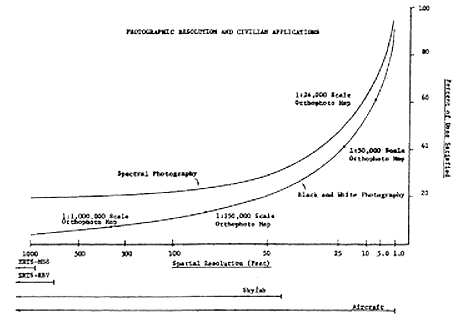
The report contains a number of very interesting figures, notably a diagram correlating sensor system ground resolution to the percentage of mapping and geographic applications that can be satisfied by imagery captured at that spatial resolution (see Figure 1). With the sensor information available following the declassification of CORONA, it is possible to situate the spatial resolutions of then-extant and future civilian sensor systems, such as LANDSAT, along with counterpart resolutions for the various CORONA camera series systems KH—1 through KH—6 (see Figure 2).
Two conclusions can be made. First, as the OMB report states, the classified systems, from very early on, were capable of much more productive geographic applications than the civilian sensor systems, then and now (and in the future). Second, the two suites of sensor resolutions are separated by a “resolution gap”—there is no significant overlap between U.S. civilian and classified sensor spatial resolutions. Although it is unmarked, one can identify a wall or barrier between them. Indeed, Mack’s landmark history of the LANDSAT system makes clear that the Intelligence Community specifically vetoed a higher resolution film-return system proposed for the early LANDSAT program, precisely because it feared any unclassified sensor that had capabilities approaching those of classified sensors would inevitably undermine national security (Mack 1990).
The OMB report limits its delineation of the differences between civilian and classified realms to spatial resolution. We might develop other critical axes, such as frequency of imaging repeat coverage, and the relative ability to cover areas on demand, or any other highly significant criteria of system performance. In effect, we can graph sensor system capabilities in multi-dimensional space, although, for clarity, we restrict the illustration to three dimensions (see Figure 3).
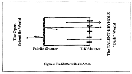
The implicit recognition of the multiple walls between realms creates–a box. Not a solid black box, though–all walls of the box communicate between outside and in by “shutters,” which one might envision as camera diaphragms, or as the venetian blinds of a hard-boiled film noire detective (see Figure 4). On one side is the classified world populated by those with clearance. On the other is the open world of civilian science. The Shuttered Box works in this manner: by coordinating the opening and closing of shutters on all sides, the view through the box is precluded at all times–there is an absolute separation between entities on either side of the box–but by opening and closing shutters in tandem, materials and people can pass securely in either direction back and forth through the box. That which can and has passed through the box includes: (1) funding; (2) people and their experience; (3) tools and techniques; (4) findings and redacted data; and (5) knowledge and science.
Figure 4.1:
Source: OMB Report of the Federal Mapping Task Force on Mapping, Charting, Geodesy, and Surveying (1973), p.140
Figure 4.2: Photographic Resolution and Civilian Applications during the Corona Era
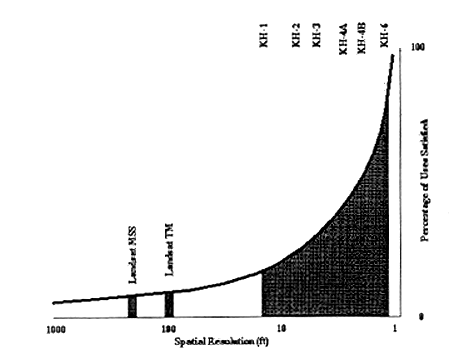
Figure 4.3: Sensor System Capabilities
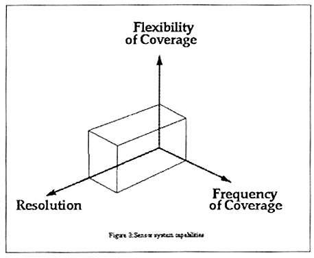
Figure 4.4: The Shuttered Box in Action
The Shuttered Box in Action
Cloud’s dissertation research is devoted to recovering the previously disguised and secret advances in Cold War geography which have reordered and transformed our world. Perhaps the two most dramatic advances with reference to contemporary U.S. society are the creation of the World Geodetic System (WGS) and the secret remapping of the United States, which was done based on intermediate imagery derived from CORONA photography. Both episodes are exemplary illustrations of the Shuttered Box in action.
The World Geodetic System
Knowledge of position has always carried strategic value, but during the early Cold War knowledge of bomber and missile launch site positions and target site locations assumed a paramount significance. The U.S. enterprise to position the planet is incorporated in the World Geodetic System (WGS), which was and is absolutely critical to aiming ICBMs–and is also one of the most beneficial and permanent intellectual achievements of the entire Cold War.
The WGS has two sets of components, related but quite distinct. Horizontal position on the planet–such as latitude and longitude–is defined in relation to a reference ellipsoid, a geometrical figure that approximates the true shape of the planet. Vertical position–height above or below sea level–is defined by height relative to an equipotential surface of gravitational attraction, which is defined as the geoid. Accurate vertical positioning, therefore, is precisely equivalent to knowledge of the planet’s gravitational field. Characterizations of position are essentially complex mathematical models fitting shapes to approximate the true contours and gravity fields of the earth. These are called datums, the singular of data, because they are generally best characterized by their unique initial points, the places where the mathematical models are affixed to the ground. For most of the 20th century, the U.S. planet has begun at Meades Ranch, Kansas, the initial point of the North American Datum of 1923. In the pre-Cold War era, all datums were continentally based and nationally centered. The critical gaps between national-level datums was recognized as early as World War II, triggered by the enormous expansion in weapons ranging represented by the V-2 rocket (von Braun 1951).
At the beginning of the satellite era, geodetic work performed by the Army Map Service and the Air Force Aeronautical Charting and Information Center confirmed both the mismatch between continentally-based datums and the inadequacies of global gravity models (DMA 1983). Geodetic progress developed through carefully monitored contacts between classified and unclassified geodetic players, involving the establishment of overt and covert geodesy education programs, initially at Ohio State University. The Defense Intelligence Agency (DIA) Mapping and Charting Directorate became the controlling authority on geodetic progress, using budget-wielding power to induce increased cooperation between Army and Air Force efforts and integrate gravity field data produced through the Navy’s Transit navigational satellite system (Daugherty interview, 21 January 1998). These efforts were necessarily concentrated on areas of the planet outside the Soviet bloc. Captured German geodetic materials seized by Allied intelligence at the close of World War II included surveys through interior Eurasia, produced originally to map the route of the Trans-Siberian Railroad. CORONA photography was used to relocate the remains of survey towers from the original surveys, allowing geodetic corrections of immense strategic value for “locking in” the positions of Soviet facilities in interior Eurasia. All these efforts culminated in the consolidation of many classified geodetic and mapping enterprises in the Defense Mapping Agency (DMA) and the still-classified World Geodetic System of 1972–the world’s first truly global datum. Degraded versions of the data set were pushed through the Shuttered Box to create the civilian USGS WGS of 1972. Refined gravity field data allowed the completion of a corrected classified datum, WGS 1984, which, in degraded form, is the basis for the North American Datum of 1983 (NAD 1983), used for all mapping of the United States and also used as the geodetic foundation for the Global Positioning System (GPS), the Universal Transverse Mercator (UTM) map coordinate system (Synder 1987).
The relationship between classified and unclassified programs was complex: the unclassified players were not just receivers in the relationship. For example, a civilian gravity researcher might collect gravity measurements, which he or she copied and pooled and gave to DOD. The data were absorbed into major computations on the dark side, adding to what became the WGS (classified). Civilian researchers got unrestricted access only to the degraded version of WGS released publicly by U.S. Geological Survey (USGS). In cartographic applications, however, civilian users were often given access to versions of CORONA photography, up to and including full-blown undegraded CORONA, but the origins of the imagery were completely disguised, and/or the fact that CORONA was a data source for the resultant civilian map or whatever was also completely disguised.
In general, the whole point of the Shuttered Box was to facilitate selected exchanges between classified and unclassified constituencies, but to do so in such a way that certain vital parameters of “security,” as self-defined by the classified community, weren’t compromised or threatened, again in their terms.
The Secret Remapping of the United States
As discussed earlier, after CORONA moved from experimental to operational mode, the superiority of CORONA imagery for many traditional mapping and geodetic efforts was quickly recognized. Extraordinary mechanisms were invented to take advantage of CORONA–but not to compromise its security, nor reveal its use for non-classified applications.
While most CORONA imagery covered Asia and Russia, about six percent of the imagery covered the United States in a systematic way to assist in civilian mapping, disaster planning and relief, pollution monitoring, and planning. Mapping with CORONA imagery was advocated by Presidential Science Advisor Eugene Fubini under the Johnson administration (Day et al. 1998). The U.S. Geological Survey, the Environmental Protection Agency, the National Oceanographic and Atmospheric Administration, and the U.S. Forest Service participated in the applications. The structures created by the USGS for CORONA applications are a paradigmatic example of the Shuttered Box in action. After testing for feasibility, a location was selected in Reston, VA for construction of a map production facility that could be entirely secured at TALENT-KEYHOLE standards. Funding for the unit was placed into the USGS budget, and the “Special Mapping Center” was opened in late 1968 (Baclawski 1997). In Baclawski’s words “the Geological Survey became the largest civil agency user of the CORONA imagery.” While mapping the United States differed from mapping the USSR and China in that an existing datum and base set of maps were available, in fact in 1973 there was not even a complete 1:250,000 map series. Thousands of maps needed revision and updating, and coverage gaps at larger scales needed to be filled. In addition, with now superior geodetic control available, the control framework “needed to be refined, updated and better integrated.”
The first use of CORONA imagery was as a supplementary source for updating the 1:250,000 national coverage. Next, attention was turned to updating the 1:24,000 series maps, using a purple overprint of revisions. No imagery needed to come out of the Shuttered Box, only the derived map products. Nevertheless, the compilation images became part of the CORONA imagery archive. While this effort was under way, a new national land use and land cover series was completed. Based on the 1:250,000 series, but clearly having a more detailed map base, the polygonal outlines of land use and land cover as classified in the Anderson set of categories was traced by hand. The Anderson classification system (Anderson et al. 1976) shows a remarkable degree of similarity to feature identification and image interpretation guides in use by the DMA, now finding their own way into the unclassified realm, such as the Civil National Imagery Interpretability Rating Scale (http://www.fas.org/irp/imint/niirs_c/guide.htm). The national land use and land cover maps were among the first digital mapping/GIS ventures undertaken by the USGS (Mitchell et al. 1977), another example of technology and perhaps expertise finding its way through the shutters.
Conclusion
CORONA and its constituencies were just one of a number of remarkable and highly secret major projects that were initiated during the administration of President Eisenhower. These projects share two major identifying characteristics, one of which seems particularly attributable to Eisenhower and his administration, the other more general. Eisenhower had been both a warrior and a college president, and he brought both realms to bear on the science and technology of national security. He made unparalleled use of scientific advisors at the highest levels of policy, and he insisted on broad implementation of compartmentalized security measures consistent with those implemented for Operation Overlord in World War II (R.C. Hall 1995).
A comparison between the principal super-systems initiated during Eisenhower’s administration is instructive, as is a comparison between the approaches and trajectories of the major scholarly analyses of these systems, and their place in advancing theory and practice in science studies. The parallel super-systems commensurate with CORONA include SAGE and other systems of enormous inter-networked computers for guidance and control, as analyzed by Paul Edwards (1996). The evolution of ICBM inertial guidance systems, the proverbial “black box of black boxes,” has been addressed by Donald MacKenzie (1990). Nuclear-powered submarines, and allied technologies of the deep seas, were recently described by Sontag and Drew (1998). CORONA as a system of overhead reconnaissance is situated within a larger set of such systems, including such vehicles as the U—2, the A—12 or SR—71, and other aircraft and spacecraft. There have been many analyses of aspects of this history, particularly the landmark history by William Burrows (1986).
These systems and the institutions that built them can be analyzed in many ways. Traditional approaches analyze policy issues at the highest levels of the organizations in question. These approaches are particularly useful for analysis of the bridging institutions that were created in response to limitations and failures in existing organizational structures; many of these problems were only identified in the process of attempting the super-systems. The rather notorious inter-service rivalries within the Department of Defense, for example, were addressed by consolidations of enterprise such as the creation of the Advanced Research Projects Agency (ARPA), and the consolidation of all military and intelligence photographic analysis facilities under the National Photographic Interpretation Center (NPIC). To meld military and intelligence access to CORONA, specifically, the bridging institution of the National Reconnaissance Office (NRO) was devised. It has recently been revealed that there is an aquatic counterpart, the National Underwater Reconnaissance Office (NURO) (Sontag and Drew 1998).
Newer approaches to the subject in the field of science studies concentrate on the socio-technical ensemble of the project or on its social organization. These studies pay particular attention to the structures and mechanisms developed in the process of realizing the objectives, and the methods by which these structures are codified into regulations and procedures that become long-term or permanent constituents of what may be considered the culture of the project’s organizations (Johnson, 1998). The analyses generally concentrate on a single specific product or program, with less attention to larger-scale systems integration. Common to both major strands of analysis is a focus on issues and actors within the projects and systems, with much less attention to relationships and impacts extending outside and beyond. 1
The concept of the Shuttered Box, however, necessarily embraces the structures of exchange between the unclassified and classified world to a larger degree than the analyses of its counterpart super-systems, in large part because of the unanticipated, multiplicative consequences of overhead reconnaissance. At the time of the super-systems’ creation the civilian world had little need for massive computer control systems, or superbly accurate inertial guidance systems–although it would soon be transformed by the smaller computer systems that SAGE induced, built with the computer chips that had been designed for ICBM guidance. Overhead reconnaissance as a source for geo-referenced information, however, was and is remarkably different. The civilian world already possessed resources critical to CORONA’s successful applications, particularly the legacies of cartographic institutions and practices, and academic resources in geographic and geodetic theory such as the geodetic sciences department at Ohio State University. More important, CORONA photography from the outset was recognized as having dual uses, with civilian and classified applications alike, a development that had little parallel among the other super-systems.
The twinned utility of CORONA triggered the evolution of the Shuttered Box. The disparities between the civilian and classified realms were not bridged, but accommodated by the mechanisms of the Shuttered Box. The solutions devised were suboptimal, and remain so. But all parties were and are served successfully enough. And all parties continue to require even more geo-referenced information. Thus, the dual use nature of overhead reconnaissance is the reason that CORONA was much more carefully concealed than the other super-systems, and remained little known for over three decades. As a result, the contemporary maps that hang on our walls today are, like Edgar Allan Poe’s “Purloined Letter,” our deepest secrets, hidden in plain view.
REFERENCES
Anderson, J.R., E.E. Hardy, J.T. Roach, and R.E. Witmer. l976. A Land Use and Land Cover Classification System for Use with Remote Sensor Data: U.S. Geological Survey Professional Paper 964, 28 p.
Baclawski, Joseph A. 1997. “CORONA: The Foundation for a Map Making Revolution.” In Corona: Between the Sun and the Earth. The First NRO Reconnaissance Eye in Space, ed. R.A. McDonald, pp. 231-41. Washington, DC: The American Society for Photogrammetry and Remote Sensing.
Bijker, Wiebe. 1995. “Sociohistorical Technology Studies.” In Handbook of Science and Technology Studies, ed. Sheila Jasanoff, et al. Thousand Oaks, CA: Sage Publications.
Burrows, William E. 1986. Deep Black: Space Espionage and National Security. New York: Random House.
Clarke, Keith C. 1992. “Maps and Mapping Technology of the Persian Gulf War.” Cartography and Geographic Information Systems 19: 80-87.
–––. 1997. Getting Started With Geographic Information Systems. Upper Saddle River, NJ: Prentice-Hall.
Cloud, John. 1997a. “Love and Hate in a Cold Climate: U.S. Civilian versus Military and Intelligence Remote Sensing, 1958—1997.” Paper presented at 2nd Annual COWHIG Conference on Unexplored Issues in Cold War History, University of California at Santa Barbara, May 21, 1997.
–––. 1997b. “I Have Found You an Argument: Amron Katz, the Landsat Debate, and the Lost Years of Earth Observation in the American Space Program.” Paper presented at the Society for the History of Technology Conference, Halifax, N.S., October, 1998.
Coppock, J. Terry and David W. Rhind. 1991. “The History of GIS.” In Geographical Information Systems: Principles and Applications, ed. D.J. Maguire, M.F. Goodchild, and D.W. Rhind, pp. 21-43. New York: Longman (Wiley).
Davies, Merton E., and William R. Harris. 1988. RAND’s Role in the Evolution of Balloon and Satellite Observation Systems and Related U.S. Space Technology. Santa Monica, CA: RAND Corporation R-3692-RC.
Daugherty, Kenneth I. 1998. Interview, 21 January, in Fairfax, Virginia.
–––. 1995. “A Revolution in Map Making,” at “Piercing the Curtain: Corona and the Revolution in Intelligence,” George Washington University, May 24, 1995.
Day, Dwayne A., John M. Logsdon, and Brian Latell, eds. 1998. Eye in the Sky: The Story of the Corona Spy Satellites. Washington, DC: Smithsonian Institution Press.
Defense Mapping Agency. 1983. Geodesy for the Layman. Washington, DC: Defense Mapping Agency. Technical Report 80-003, Edition 5.
Devorkin, David H. 1996. “The Military Origins of the Space Sciences in the American V-2 Era.” In National Military Establishments and the Advancement of Science and Technology: Studies in 20th Century History, ed. Paul Forman and Jose M. Sanchez-Ron. Dordrecht, The Netherlands: Kluwer Academic Publishers.
Federal Mapping Task Force. 1973. Report of the Federal Mapping Task Force on Mapping, Charting, Geodesy and Surveying. Washington, DC: Executive Office of the President, Office of Management and Budget.
Foresman, Timothy M., ed. 1998. The History of Geographic Information Systems. Perspectives from the Pioneers. Upper Saddle River, NJ: Prentice-Hall.
Forman, Paul. 1987. “Behind Quantum Electronics: National Security as Basis for Physical Research in the United States, 1940—1960,” Historical Studies in the Physical and Biological Sciences 18, 1, pp. 199-229.
Hall, R. Cargill. 1995. “The Eisenhower Administration and the Cold War: Framing American Astronautics to Serve National Security,” Prologue 27 (Spring): 59-72.
–––. 1998. “Postwar Strategic Reconnaissance and the Genesis of Corona.” In Eye in the Sky: The Story of the Corona Spy Satellites. Edited by Dwayne A. Day, et al. Washington, DC: Smithsonian Institution Press.
Hughes, T.P. 1983. Networks of Power: Electrification in Western Society, 1880—1930. Baltimore, MD: Johns Hopkins Press.
Hounshell, David. 1997. “The Cold War, RAND, and the Generation of Knowledge, 1946-1962.” HSPS 27, 2: 260.
–––. 1998. “Science, Technology, and Democracy in the Cold War and After: A Strategic Plan for Research in Science and Technology Studies.” (Web: http://www.hss.cmu.edu/coldwar/NSFbooklet.htm).
Johnson, Stephen. 1999. “The Organizational Roots of American Economic Competitiveness in High Technology.” Space Times. Washington, DC: American Astronautical Society.
Klass, Phillip J. 1971. Secret Sentries in Space. New York: Random House.
Laird, Pamela. 1998. “Stories Against the Current.” SHOT Newsletter, Society for the History of Technology, n.s., no. 79 (April): 2-3.
Latour, Bruno. 1987. Science in Action: How to Follow Scientists and Engineers Through Society. Cambridge: Harvard University Press.
Latour, Bruno and Steve Woolgar. 1979. Laboratory Life: the Construction of Scientific Facts. Princeton: Princeton University Press.
Leghorn, Richard S. 1955. “U.S. Can Photograph Russia from the Air Now: Planes Available, Equipment on Hand, Techniques Set.” U.S. News & World Report (5 August 1955): 70-75.
Mack, Pamela E. 1990. Viewing the Earth: The Social Construction of the Landsat Satellite System. Cambridge: MIT Press.
MacKenzie, Donald. 1990. Inventing Accuracy: A Historical Sociology of Nuclear Missile Guidance. Cambridge: MIT Press.
Madden, Frank. 1996. The Corona Camera System: Itek’s Contribution to World Security (self-published monograph).
McDonald, Robert A. 1995. “Corona: Success for Space Reconnaissance, a Look into the Cold War, and a Revolution for Intelligence,” Photogrammetric Engineering and Remote Sensing 61, 6 (June): 689-720.
McDonald, R.A., ed. 1997. Corona: Between the Sun and the Earth. The First NRO Reconnaissance Eye in Space. Washington, DC: The American Society for Photogrammetry and Remote Sensing.
McDougall, Walter A. 1985. The Heavens and the Earth: A Political History of the Space Age. New York: Basic Books, Inc.
Mitchell, W.B., S.C. Guptill, K.E. Anderson, R.G. Fegeas, and C.A. Hallam. l977. GIRAS–A Geographic Information Retrieval and Analysis System for Handling Land Use and Land Cover Data: U.S. Geological Survey Professional Paper l059, l6 p.
National Academy of Sciences. 1969. Useful Applications of Earth-oriented Satellites: Summaries of Panel Reports. Summer Study on Space Applications. Division of Engineering, National Research Council. Washington, DC: National Academy of Sciences.
Office of Management and Budget, Executive Office of the President. 1973. Report of the Federal Mapping Task Force on Mapping, Charting, Geodesy and Surveying. Washington, DC: U.S. Government Printing Office.
Pace, Scott, et al. 1997. Using Intelligence Data for Environmental Needs: Balancing National Interests. Santa Monica, CA.: Rand Corporation
Richelson, Jeffrey. 1984. “The Keyhole Satellite Program.” Journal of Strategic Studies 7 (June): 121-53.
–––. 1998. “Scientists in Black.” Scientific American 278: 48-55.
Ruffner, Kevin C., ed. 1995. Corona: America’s First Satellite Program. Washington, DC: CIA History Staff, Center for the Study of Intelligence, Central Intelligence Agency.
Schlesinger, William H. and N. Gramenopoulos. 1996. “Archival Photographs Show No Climate-induced Changes in Woody Vegetation in the Sudan, 1943—1994,” Global Change Biology 1: 137-41.
Sontag, Sherry, and Christopher Drew, with Annette Lawrence Drew. 1998. Blind Man's Bluff: The Untold Story of American Submarine Espionage. New York: Public Affairs.
Starr, Lowell. 1995. “A Revolution in Mapmaking,” at “Piercing the Curtain: Corona and the Revolution in Intelligence,” George Washington University, May 24, 1995.
Synder, John P. 1987. Map Projections–A Working Manual. U.S. Geological Survey Professional Paper 1395. Washington, DC: U.S. Government Printing Office.
von Braun, Wernher. 1955. “Why Guided Missiles?” Library of Congress. Von Braun Papers, Box 46.
Wheelon, Albert. 1995. “Lifting the Veil on CORONA,” Space Policy 11: 249-60.
Endnote:
Note 1: The exception is MacKenzie (1990). Back.