|
|
|
|
CIAO DATE: 07/06
![]()
Cooperation on Tsunami Warning Systems
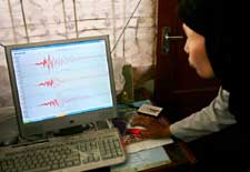
A technician analyzes seismic data recorded by a digital seismograph at a geophysical station in Banda Aceh, Indonesia, in November 2005.
(DITA ALANGKARA ©AP/WWP)
In the 14 months since a magnitude 9.15 earthquake and tsunami killed more than 200,000 people and displaced millions in a dozen Indian Ocean countries, those nations and their international partners have worked hard to make sure that future natural disasters never again take such a toll. Plans for an early warning system for the region took form at meetings held throughout 2005 in the diverse locales that reflect the many contributing international partners—Japan, France, Hawaii, Australia, and, most recently, India.
In Hyderabad, India—where the second session of UNESCO's International Oceanographic Commission (IOC) Intergovernmental Coordination Group (ICG) for the Indian Ocean Tsunami Warning and Mitigation System was held—representatives from many Indian Ocean nations met from December 14 to 16. Along with observers and advisers from Germany, Japan, and the United States, participants discussed the technical details of a fledgling system for detecting tsunamis and other natural hazards. The new system is taking shape in Australia, India, Indonesia, Malaysia, the Maldives, Sri Lanka, Thailand, and other countries, where nothing of its kind existed previously.
Since the tsunami occurred, many countries, including the United States, have offered financial and technical support for the complex undertaking. Through the U.S. Indian Ocean Tsunami Warning System Program, U.S. agencies will spend $16.6 million over two years to help develop early warning capabilities for tsunamis and other hazards in the Indian Ocean and to support the IOC's lead in developing an international warning system with seismic and ocean data sharing for 16 countries.
Developing such a system takes time, because warning people about imminent tsunamis and other hazards requires an end-to-end system—one that includes hazard and risk assessment for each nation, hazard warnings and preparedness, ocean observations, data management, forecasting, forecast and warning dissemination, capacity building for hazard detection and prediction, population warning and communication, and disaster preparedness. Each component of such a multinational system must be able to communicate within the system and with other systems around the world.
On December 26, 2004, when the Indian Ocean tsunami occurred, such a system existed only in the Pacific Ocean basin, where more than 85 percent of the world's tsunamis occur. The Pacific Tsunami Warning Center (PTWC) in Hawaii is part of the U.S. National Oceanic and Atmospheric Administration (NOAA) National Weather Service. Before that date, the PTWC served the Pacific Basin as a regional and long-distance tsunami warning center and as a local tsunami warning center for Hawaii. Today it is serving as an interim warning center for the Indian Ocean—in cooperation with the Japan Meteorological Agency (JMA), which issues bulletins for hazard-related events in the Indian Ocean—and the Caribbean until systems are in place for those regions.
Thanks to a massive international effort, the elements of such a system are coming together in the Indian Ocean. Over the last 12 months, according to UNESCO, 25 Indian Ocean nations have established communications centers that allow them to receive hazard advisories based on seismic information from the PTWC in Hawaii and the JMA in Tokyo.
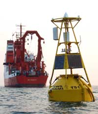
This buoy is part of a tsunami warning system developed by GITEWS (German-Indonesian Contribution for the Installation of a Tsunami Warning System). Sensors on the ocean floor and buoys on the surface of the sea transmit data about earthquake and tsunami activity to observation stations.
(FADLAN ARMAN SYAM ©AP/WWP)
The U.S. Geological Survey (USGS) is establishing several new seismic monitoring stations at the source zone of the December 2004 tsunami—near the Sunda fault off the island of Sumatra in Indonesia. To do this, the agency is working with the governments of Indonesia, Thailand, Sri Lanka, India, and the Maldives to improve the monitoring, detection, and notification of potential tsunami-generating earthquakes.
Because there is only a 15- to 20-minute warning time between when an earthquake occurs and when waves strike the shores of Indonesia, seismic methods—rather than ocean sensors—are the best way to detect an earthquake there. Up to 60 seismometers are being installed, mainly in Indonesia but also in surrounding countries; the long-term goal is to have more than 100 seismometers in the region. In this effort, the USGS is working with the JMA, the German Ministry of Science and Technology, and the Chinese Earthquake Administration.
Seismic information can tell these national centers that an earthquake of a certain magnitude has occurred in a specific location, but not whether a tsunami is on the way. Deep-ocean tsunami detection instruments are needed to detect a teletsunami—one that is moving across the ocean toward distant coastal areas. No such instruments are operational in the Indian Ocean, but several countries in the region—including India (with help from Germany), Australia, and Malaysia (with help from a commercial company, Fugro, in the Netherlands)—are working to deploy deep-ocean tsunami detection instruments.
Tide gauges can also help determine whether a tsunami threat is real. In the Indian Ocean region, 32 such gauges have been upgraded so they can be used for tsunami detection as part of an international IOC-World Meteorological Organization (WMO) network called the Global Sea Level Observing System for climate, oceanographic, and coastal sea-level research.
Another international system has also been pressed into service for tsunami detection. The Global Telecommunications System is a global network for transmitting meteorological data from weather stations, satellites, and weather prediction centers that has been modified, with help from WMO and NOAA, to carry tsunami-relevant information.
"As we found on December 26 [2004]," says Eddie Bernard, director of NOAA's Pacific Marine Environmental Laboratory in Seattle, Washington, "a tsunami can be a global phenomenon, so it's really important that when someone has a tsunami, the rest of the world knows about it."
Cheryl Pellerin, staff writer
U.S. Department of State